Putting the Dysynni Valley on the map - literally

By Ros Dodd
Beautifully made to scale (1 foot:1 mile), the 3D Bro Dysynni Map shows not only the valley's distinctive features - Cader Idris, Craig yr Aderyn (Bird Rock) and the Afon (River) Dysynni curling its way 14 miles to the sea - but the smallest details such as gates, trees, boundaries and public footpaths, all intricately woven into the patchwork landscape.
Three decades on, the woman who led the ambitious project, Jane Whittle, now 92, has embarked on a new large-scale fabric creation, a wall hanging based on an ancient book called The Mabinogion, a collection of the earliest-known Welsh prose stories dating from the 12th and 13th centuries.
"We started before Covid, but then it was put on hold," explains Jane, an artist who lives in Llanegryn. "We recently started it up again, but we don't have enough people at the moment. If anyone from the area would like to get involved, we'd be delighted to hear from them. They can contact Rosey White on 01654 710959."
Eighteen people created the Bro Dysynni Map, which was part of the UK-wide Parish Maps Project launched by environmental organisation Common Ground to mark the Year of the Environment in 1987. More than 1,000 maps were made all over Britain to celebrate and help to preserve places people considered important. However, almost all of them were wall maps. Only two were three-dimensional: the Redlynch Map, of a chalk landscape in Wiltshire, which Jane - who lived there before moving to Wales - also led, and the Bro Dysynni, which was the largest.
The 3D model idea was hers. "As a child, when I was ill, I would be tucked up in a patchwork quilt. I'd run my fingers across it, imagining it was a natural landscape. So when it came to map project, I thought about creating a soft quilt, which we did in Wiltshire, but in the case of the Bro Dysynni, there was a mountain - Cader Idris - so a quilt wouldn't quite work. We needed to make a model."
Creating that model took nearly three years, with work starting in October 1992. The base was on chipboard with layers of polystyrene, one to each 30-metre contour traced and enlarged from the OS map. All this was then covered in 'teddy bear' stuffing.
"Each person chose a patch of land, walked it and got to know it well," explains Jane. "Once they'd created the outline of their particular section, they collected materials from the communal rag bags and then began sewing at home, using silks and wools, emphasising those things most important to them in individual ways - flora, fauna, archaeology, local history and legend, geology and geography. I worked mostly on the higher terrain, as well as the public footpaths."
The different sections were then attached to the base in Jane's barn to create the finished model.
Among the participants were Ann Roberts and her late mother, Rhona Wooley, from Bryncrug, whose patch was the Rhoslefain fields. The only man involved was Colin Askey, a former steelworker from the West Midlands who'd settled in Tywyn and knew Jane through keeping chickens in her orchard. Although he'd made items out of fabric before, he'd never done anything on the scale of the Bro Dysynni Map.
"I had no idea it would be so big," remembers Colin, now nearly 81. "I did a lot of the work in my garage, with the doors open, and people would stop and say, 'what on earth are you doing in there, Colin'? I really enjoyed it, because I'd had to retire early due to ill health and this was something I could do sitting down and at my own pace."
Only one group member was an experienced embroiderer. Most people learned as they went along. "I even used pliers to do my stitching," laughs Colin, whose section of the valley was over Foel Wyllt from Abertrinant to Bryncrug. "I've always loved the area - and I love the people. I really enjoyed doing the map - it was a lovely time."
 |
| Colin Askey working on the map in Jane's barn |
Towards the end of the project, the group was invited to display the map at Llanegryn village fete, allowing people to write down details of the map that weren't right. "For example, a farmer could say, 'there's not a gate there any longer,' so we were able to change it," says Jane.
In 1996, the year after its completion, the map was put on show at the Barbican in London. After returning to Wales, it was displayed briefly at St Cadfan's Church, Tywyn, before moving to St Michael's, where it took up residence in the vestry, protected by a Perspex cover funded by the Calouste Gulbenkian Foundation.
"The most important thing about the Dysynni Valley is that this very ancient land is truly unspoilt," observes Jane. "The national park and Peniarth estate have largely preserved it. When you walk on a Bronze Age track like the Ffordd Ddu, you can almost feel the people who lived here thousands of years ago, because apart from the planting of trees and installation of drainage systems the places haven't changed very much since then."
The creation of the Bro Dysynni Map helped those involved to feel more connected to the area.
"The better you know a place, the more it means to you. By creating something together from what we value, we may help to prevent all this from being spoilt. It is one way of cherishing and celebrating the beautiful valley in which we are so lucky to live."
Jane recently returned to St Michael's Church for the first time since before Covid and was delighted to see the map again.
"I took along cleaning materials, but I didn't have much to do because it is obviously being well looked after. I hope it stays at St Michael's for many more years to come. It needs to be in a place where people can see it, because it's a record of the Dysynni Valley in 1995 made by people who lived here. I'm actually very proud of what we did."
 |
| St Michael's Church, where the Bro Dysynni Map is housed |
 |
| The Bro Dysynni Map is displayed in the church vestry |
 |
| The embroidered 3D map under its Perspex cover |
 |
| Jane working on the map in the '90s |
 |
| Rhona Wooley from Bryncrug helped create the map |
 |
| Layers of polystyrene were glued together on a plywood base |
 |
| The map takes shape in Jane's barn |
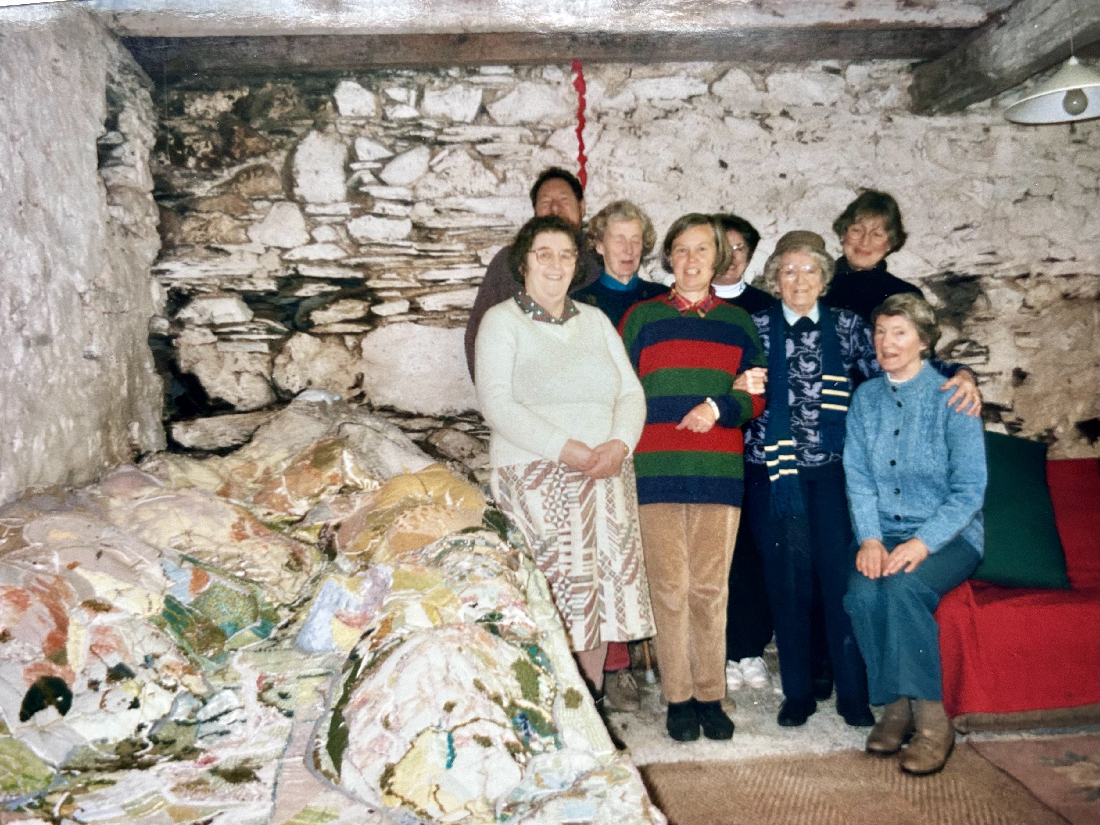 |
| Some of the 18 volunteers who created the Bro Dysynni Map |
 |
| A local farmer looks over the model |
 |
| A material Bryncrug! |
 |
| Completed and on display at St Michael's |

